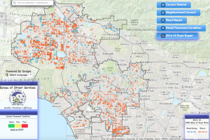
For this blog I chose to look at the data set entitled data set entitled “Street Grades” from the L.A. Controller Office. This report contains information regarding the quality of the roads in Los Angeles. This project utilizes a large interactive map in order to showcase the data it provides. The map is powered by Google. Users have the ability to zoom over different regions of the map so that they may see information more clear. There are also five different features to help organize the data on the map. They are as listed: council district, neighborhood council, road repair, street pavement conditions, and the 2014-2015 Road repair. These categories can be turned on and off as well as combined together to showcase desired data. What each feature dose is fairly simple, council district identifies the different districts in the city, neighborhood council identify the different neighborhoods, road repaid highlights areas that are both currently receiving repair or proposed repair, street pavement condition illustrates the condition of the street, and the road 2014-2015 road repair feature shows what repairs were made and when they were made on the map. The Street Pavement Condition feature however is arguably the most important data set on the map. It’s rankings are based on the Pavement Condition Index in order to accurately identify the road’s true condition. The street pavement condition option grades the roads on a 0-100 scale as well as gives a small comment on the condition of the road. This means that the Pavement Condition Index becomes the data’s ontology. As defined by Wallack and Srinivasan, ontology is, “An essential shared infrastructure for individuals to function as a group” as well as “also act[ing] as objects that create and negotiate boundaries between groups.” Groups that are most likely to find the data most useful is anyone who drives in the Los Angeles area. The dataset showcases important construction, roadwork, and poor pavement conditions to alert drivers; construction also slows down traffic, making this data a useful tool to avoid getting suck in the city. This dataset describes the amount of roadwork completed in the Los Angeles region and the condition of our roads. It explains to us how the city is attempting to make our conditions better both through completed constructions and proposed. One useful feature that the dataset leaves out is estimated completion time. This feature would be useful to help users know when to avoid the area. From the point of view of the city when viewing this data-set I would believe that this data illustrates how “we” are helping better the city of Los Angeles. The data helps to visualize ongoing projects and keep record of what the city is doing with the roads.