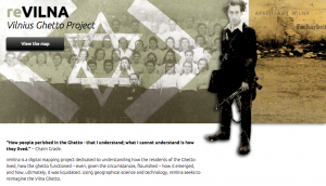
This week, I had the pleasure of exploring reVILNA: Vilnus Ghetto Project and taking a look at the maps provided. The project’s overall purpose is to be a digital mapping project that helps understands how people lived in the Ghetto. how it emerged and functioned as a structure, and how it was ultimately liquidated of its residents.
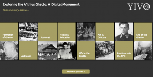
At the home page, one can click on a button that says ‘View Map’ which will lead them to a different page; the page is full of numerous ‘stories’ that users can click on. Among these stories are the formation of the Ghetto, Aktionen, Judenrat, Health & Education, Art & Culture, and so on. Each of these stories contain a description of the content and a gallary of images over a map; once exited, users can see what significance each story has within the Ghetto. Below the bar of stories, however, there is a button to ‘View on your own’ which when clicked, refreshes the page to become the interactive map alone.

Accompanying the map is a sidebar that acts as a timeline and description of significant locations and events, as well as a legend on the other side that one can select and deselect to view either all at once or individually.
This digital mapping project is very well done in how it takes users back to a place that many may not have even known to exist in a time of such conflict and turmoil; I myself did not know about this particular ghetto. reVILNA is thorough in the stories given and effort had been clearly made to make sure each description, image, and location is as accurate as restored as possible. Everything from the home page to the map itself is understandable and most importantly eye-opening in how it engages users to look through real-life stories on their own, to truly learn about what life was like in this place and who these people were.
On the other hand, the only thing that this project, I feel, is lacking in was a more detailed introduction to the project. I did not know that Vilnus was a Jewish Ghetto, nor did I know where it as located until I navigated the site a bit more; I think it would have been better to have that information in a more accessible place, like on the home page, so users aren’t confused as they interact with the map and whatnot. Although the interface is organized and aesthetically pleasing, the map is the only real ‘meat’ of this project, for lack of words– maybe, to complement the map’s purpose, digital 3D renditions of the living quarters, recreated recordings, and other methods of mapping and visualization would be nice.
An interesting alternate map would be to layer over other ghettos during this time to better visualize what these places did and did not have in common, as well as both conferring and contrasting facts about each place. It would also give great aid in visualizing the reality of the Jewish ghettos; by layering over images it can really show the sheer size and ethical implication they posed to the Jewish population during WWII.