I chose to examine the map Locating London’s Past. This mapping project compares two early maps of London, John Rocque’s 1746 version and the 1869-80 Ordinary Survey map, which was the first accurate map of London. These geo-referenced maps were then indexed with historical databases that documented various records such as taxation, elections, coroners’ records, parish registers, and archeological evidence. The user is able to navigate between drawn and modern maps of London and individual sets of data. The user is asked to choose a base map on which to begin mapping data. When a specific data set is selected, the map feature digitizes the area of most concentration on the map itself or provides pin points to indicate the precise location of a data set. The represented data is color coordinated and David Turnbull writes in his project, “Maps are Territories” that maps are generally defined as selective, as the cartographer or printer maker can decide what to include or exclude. Locating London’s Past, I believe, gives a pretty well rounded representation and as Turnbull states, allows the data to be indexical as it recognizes its connections to humanity.
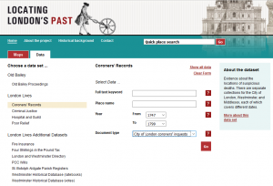
The data sets on the site allow for the user to both interact with the map, and cross reference early drawings of London with modern day maps while providing extensive information on the data set themselves. I would make the argument that this site largely focuses on the data presented, rather than the graphical interface of the map. This is also attributed that the interactive map is displayed on its own individual tab on the site and the user is expected to go back and forth between this and the “Data” tab. The data tab is important to have because it provides citations of information, however I think that it would be more been more effective to have the data and maps on the same page in order to see changes made on the map as you play with data sets.
Nicely done! Very clearly written introduction to the project. What did you think of the data types? Do you think the project could have benefitted from any additional data?