The introduction to reVilna’s website opens with a quote from Chaim Grad: “How people perished in the Ghetto – that I understand; what I cannot understand is how they lived.” This week I took a look at reVilna, a digital mapping project that examines the Vilna Ghetto as a living, breathing environment. Using sources such as “memoirs, archives, original Ghetto documents and artifacts, and oral and historical accounts” reVilna was able to create an immersive map of the Lithuanian Ghetto.
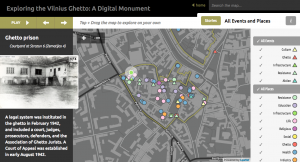
Navigating the website was fairly intuitive. Users could choose to explore “Stories” that gave a brief description and timeline of events such as the “Formation of the Ghetto”, “Health and Education”, and “The End of the Ghetto.” Another option was to “Explore on your Own”, allowing the user to autonomously explore the map of the Vilna Ghetto. Both of these options act as enlightening windows into the dynamism of life in the Ghetto.
This project was an interesting way for scholars to humanize a tragic historical event, allowing for a unique opportunity to breathe life into one of the many ghettos from WWII era Europe that are often written off as one of an endless amount of horrors during the Holocaust.
The website is teeming with information concerning the Vilnius ghetto, however its accessibility can be at times somewhat tenuous; the creators of the site are presumptuous in the level of knowledge its viewers possess, never truly giving a generalized account of the grand historical moments leading to the establishment of ghettos or providing information regarding the Lithuanian cultural and geographical setting. It should also be of note that the website does not provide adequate zoom functioning in the map, preventing users from easily clicking on all of the featured icons on the website.
Overall, I feel that reVilna had a powerful and successful mission. It provides a dynamic way to learn about a rarely explored aspect of the Holocaust. It would be interesting for this website to provide a comparison of the Vilna Ghetto then and now, giving a contemporary link for this historical site.
Hey there!
I was writing about this too and I completely agree with the zoom function of the maps and how it is detrimental to the project. You also made a good point about the lack of detail and that there is little context and explanation beyond mere description. Another thing I liked about your post is how clear and concise it was!