
The Mappa Mundi is an artefact located in Hereford Cathedral, England. The cathedral is well known for both this artefact as well as one of the few remaining chained libraries in Europe. It is an interesting map of the known inhabited world at around 1300. It is mapped from the point of view of Christian Europe and includes Europe, Asia, and North Africa. Jereusalm inhabits the center of this map. The map is particularly interesting as it is mapped far more from a cultural, mythological, indeed humanist perspective rather than a political or geographical perspective. The east occupies the area north of Jeresualm as it is where Christians look to for the second coming of Christ. The map is created on a 5’2″ by 4’4″ piece of vellum.
The Mappa Mundi online project scans this physical artefact for online exploration. A team from Factume Arte utilized 3D laser scanning, composite photography, and photogrammetry in order to create digital 3D replicas. Composite photography was used for encoding the map in color. This technique involves taking hundreds of macro photos and stitching them together to form one megapixel image. The scanning was done via the Lucida 3D scanning system which used a low intensity laser over a custom designed platform to scan the features of the map without injury to the original. Finally, photogrammetry was used to capture the border and edges of the map.
Once the scanning was complete, the map was compiled and overlaid with notes and features. The online display includes pins which you can click and zoom into annotated with descriptions of the image and translations of any written language. There is a view additional details link which I was not able to access however. The exhibition is likely still in development as the loading screen mentioned 500 drawings, 420 cities and towns, and much more which were not displayed in the select few annotated pins available. I would personally like to see a pan feature added, change of perspective, and personalized zoom in and out. Much like google maps with the additional capability of change of camera views. An animation software like blender or maya would be a more apt comparison.
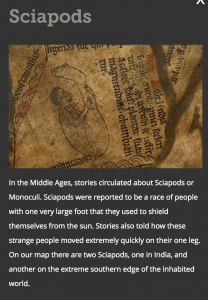
One of my favorite sections of the project was the strange creatures section. The sciapod was my favorite. It is too entertaining to leave to the reader’s personal exploration, so I’ve included an image excerpt below:
Along with this are some great descriptions and pictures of creatures found throughout the world at the time.
All in all the project was a delightful surprise which made me aware of an exhibit and artefact I did not know of before. I am now more likely to visit in person to explore the physical artefact. The mapping of the world from a cultural and humanitarian perspective was also delightful as it speaks to something we would do as children. It is good to know that medieval childhood is preserved till today. The child does not die within us as we age.
Hi,
I agreed that the project is inspiring. Being in today’s world where all things are digitalized, having historical arts that are preserved digitally and are accessible to everyone across the globe is one of the important goals of Digital Humanities. I also agreed that the project is interesting and interactive. It would inspire more people to learn more about arts in the middle age.
Hi,
Sometimes when people think of history and maps, a wave of disinterest may cross over into their mind. I agree that this project was a “delightful surprise” as it revitalized an ancient artifact and presented it in a way that was exciting and engaging to explore! The processing technology used in order to digitize a lot of the information from the source was perfect as it made it interactive and fun to learn about this piece of history.
Hi,
I really liked that you provided an extensive background of how the 3D scan and all the effects on the digital map are created which is very informative. I agree with your suggestions on how can the product be improved such as adding features such as variable perspective to view the map.
I thoroughly enjoyed reading your analysis of Mappa Mundi! I appreciate how you explained each technique used to process the map in depth. Initially I had a vague idea of what each technique entailed but you explained how they’re used in this project in a concise manner. I agree with your suggestion of adding a pan feature. I think it would make the project even more interactive and exciting. Thank you for sharing the snippet about sciapods. That is hands down one of my favorite sections of the project as well!