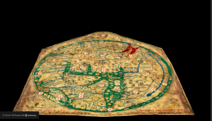
I decided to explore the Mappa Mundi, which is currently being preserved in Hereford, England. Mappa Mundi, Latin for world map, has the recognition of being the world’s largest medieval map known to still exist. Experts believe it was made around the 1300s and has since survived negligence and the Second World War. The map depicts the history, geography and destiny of humanity as it was known to Christian Europe. Included in the map along with Europe is Asia and North Africa. Based on a Christian framework, Mappa Mundi goes on to map out biblical events such as the Garden of Eden, Noah’s Ark, Jerusalem (the centre of the map), as well as depicting Christ on the top of the world. Lastly the map was made from vellum, fine parchment made originally from the skin of a calf.
Sources – Creators of the map sought to educate by mapping natural history and classical legends while reinforcing religious beliefs during its time. I belief the map derived from biblical tales as well as the extent of the geographical knowledge known to man during its creation. From the map readers could learn about legends and myths, while obtaining of where Christian landmarks were located. Again this is all based on biblical beliefs.
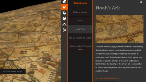
Processing- Through the “Explore Now” tab on the site the viewer is able to navigate throughout the map and given the opportunity to switch between different layouts. The site makes the map easily accessible, formatting its site to be a click away for wealth of information. The user doesn’t have the trouble of having to go through the entire map, instead labeling the various aspect of the map for you.
Presentation – The map is presented in three formats: 3D, color enhanced and the original. Thru the DH site each layer presents the map in a different light. The 3D version of the map helps the viewer see the wear and tear of the vellum that were caused before it was made into a map (insect bite to the animal’s skin) and after (normal wear and tear from a 1300 map). The colored map helps the viewer see the map better. The manner in which the map is presented to the viewer is simple and straightforward. It includes point of interest that are accessible by a click of the mouse and labeled by category such as: Myths and Legends, Bible Stories, Beast of the World and more. https://www.themappamundi.co.uk/mappa-mundi/