The source in the project is an early 14th century medieval map termed modernly as the “Mappa Mundi.” The map is drawn on one side of a singular calfskin. It was written on the flesh side of the animal skin, meaning the inside part of the skin (opposed to the skin side that can be seen outwardly). There is a natural bubbling up effect that occurs in the material the map because it is on the skin of a animal. Therefore it is not flat. The dimensions of the piece according to the website 3D tab is “1.5 m high, 1.3 m wide and 0.7 mm thick.” It is geographically imperfect however it is a beautiful representation of 1300s map maker’s view of the Western Christian world; it especially highlights the important characters, places and mythology that map choose to represent. It is believed by researchers that it was that the sketch was first and the words were added later, due to evidence such as words fitted around the drawings. The impressions in it’s surface were made from ink as well as pressure from the writing utensil. There are other pigments that were used to make this map colorful. The physical copy of the map is displayed at
Hereford Cathedral, 5 College Cloisters, Cathedral Close, Hereford, HR1 2NG
It is part of the Hereford Cathedral’s Chained Library Collection and is displaced in a permanent exhibit called the “Mappa Mundi.” The digital viewing of the map is available at https://www.themappamundi.co.uk/mappa-mundi/.
The source is processed in many ways. The 3D section that created as allows the user to both look up at the physical characteristic of the map such as the folds and indentation by ink and the nature of the material. Then there is the writing and drawings on it that shows the aspects the map maker choose to represent in words, symbols and images. The website combines several different projects into one. It is slightly unclear who paid for and constructed the digital site however the Factum Arte Foundation made the 3D scan of the surface and the Folio Society created the color enhanced image in conjunction with the Mappa Mundi Foundation. The information from the map is also processed qualitatively through the close attention paid to individual drawings.
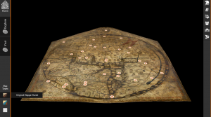
The Mappa Mundi is presented on a website through three different viewing: the Original Mappa Mundi, a Color Enhanced version, and a 3D scan version. It is also an interactive map that can be looked at in closer detail to see certain drawings and writing in closer detail the website choose to highlight. The website is split the map into a couple of different sub-subjects including myth and legends, bible stories, beasts of the world, strange people of the world, towns and cities, and 3D scan. This organization the information it to digestible tabs so aspects of the map are also explained by short description in greater detail.
I also did this project and liked your inclusion of google maps location for the exhibit. Describing that you like the physical artefact as well was important for me since it recognizes the digital is just a representation of the physical.