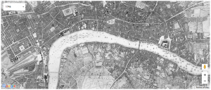
The “Locating London’s Past” (LLP) DH mapping project allows you to search various digital datasets relating to early modern and eighteenth-century London and map selected data onto a fully GIS compliant version of John Rocque’s 1746 map. John Rocque’s 1746 map is the most detailed map of London during its time, which took 10 years to create.
The LLP uses maps to create a GIS interface based on John Rocque’s 1746 representation of London on which users can map and visualize data concerning texts and artefacts that relate to London in the 18th century. The project aims to relate the 1746 map representation of London to the 1st accurate OS map of London from 1969-80 to modern Google Maps environment. Users can even enter the familiar “street view” of Google Maps to view the streets of modern day London and compare it to 1746 London. To visualize data, they can select and customize data related to 18th century records of crime, poor relief, taxation, elections, local administration, plague death and archaeological finds in London. The data will then be presented on an interactive map showing the regions to which the selected data relate, and a pop-up window is available for each region that shows more information and links to the record of the data.
It seems to me that this map assumes users have general knowledge on the history and geography of London. I was a bit confused as I was trying to analyze further meaning to the correlation of the data and the regions that were highlighted when the data is mapped. The maps do, however, effectively reveal and visualize data on 18th century London. Since the project creates the GIS interface based on the 18th century representation of London, regions that have been added and developed in following centuries are left out in the maps. Thus data is only mapped on regions present during the 18th century, which may be unuseful for people researching about current day London. Furthermore, although the project contains a good number of informative datasets related to London, the data is still kind of limited to very few specific topics. Thus users don’t get a very complete picture of historical and modern-day London.
If I were to imagine a different map, I would present the entire current territory of London on the GIS map, which will also show the expansion of London throughout the centuries when compared with the 1746 map. A more diverse collection of datasets available to map would also be more effective for users to learn about London. Some datasets that I would like to add are important landmarks, well-known businesses, art or architectural sites and features, etc.