For this week’s blog post, I decided to explore the Mappa Mundi by reverse engineering it, dividing the digital project into 3 categories: sources, processing, and presentation. You can take look at the site for yourself by clicking the link (https://www.themappamundi.co.uk/index.php) or the image below.
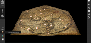
Created around the year 1300, the Mappa Mundi, is considered one of world’s unique treasures, as it is the only complete world map to survive the Middle Ages. Not only does the Mappa Mundi depict the geography of Christian Europe, it displays the history and theology of what was understood at the time; biblical stories and mythical creatures are portrayed throughout the round and flat depiction of Earth. The map includes Europe, Asia, and North Africa as continents and Jerusalem as the center of the world.
The main source of the site is the Mappa Mundi itself. The map is constructed on the flesh side of a 1.5 m high, 1.3 m wide and 0.7 mm thick sheet of vellum, or calfskin. However, how did the creators of the site decipher what the etchings on the vellum mean to display the different artifacts and details? They used documents and books from the Hereford Cathedral Chained library, the largest surviving chained library, to understand the biblical and historical context of the Mappa Mundi. Another source is therefore the Great Charter of Liberties or “Magna Carta.” The Magna Carta is considered to be one of the most important documents in history because it laid the foundation of common English law, restricting the rule of the King and allowing for more freedom of the individual. Based on the writings of the Magna Carta, researchers were able to more accurately understand the Mappa Mundi. Close-up images of all 3 of these sources were also used.
The different forms of processing of the Mappa Mundi allowed for different visualizations. Through visual scanning, visitors of the site can explore the Mappa Mundi in its original format, a color enhanced reproduction done by the Folio Society, or the 3D visualization of the surface details done by Factum Arte. The no-contact 3D scanning process was conducted using a low-intensity laser scanner and 2 black and white cameras to convert the 2D map into a 3D visualization.
The resulting presentation of this project is the Mappa Mundi being transformed into an interactive website, enabling the site visitor to easily explore the different aspects of the map. You can view the map in its original format, a color enhanced version, and a 3D scanned version. Each artifact on the Mappa Mundi is then divided into different sections like Myths and Legends, Bible Stories, and Beasts of the World, that are further divided into specific subsections. By clicking on each dot or section on the right panel of the site, you are able to explore the meaning of each respective location on the map.
I especially enjoy this site because of its clean organization. Not only are you provided with 3 different ways to visualize the Mappa Mundi, you are able to explore the details of it with a clear explanation. I found the 3D scanned version of the Mapa Mundi to be particularly fascinating because I never knew so much can be learned just based off the forensic studies of markings on a calfskin.
I love all the detail you’ve provided about the map! What do you think about the way the authors presented the map? Is it effective?
Great explanation of the site! I think the effect of having three separate maps really pulls in the user and makes them more likely to stay around and explore the map in detail.
I enjoyed reading your thorough detail! I liked how you wrote about the original Mappa Mundi and its significance in religion and humanities. It’s interesting how the Mappa Mundi and Magna Carta both survived so much time. If only the Mappa itself had survived, we may not have been able to learn as much from it.