In this post I will be exploring the Mappa Mundi, a medieval treasure created in the time of Christian Europe. I will be examining three different components of this project: source, processing, and presentation. You can explore the map on this site to learn more!
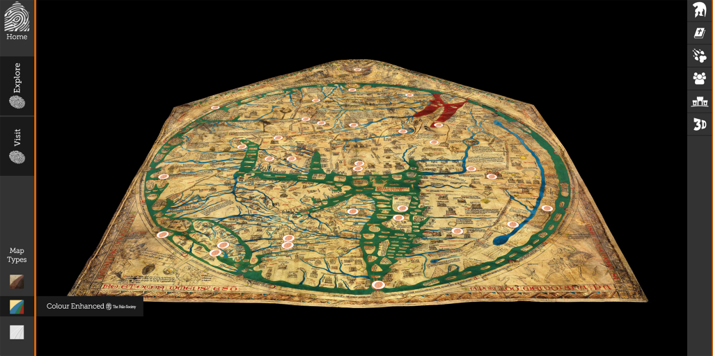
Source – The source is the map itself dated in the year 1300. The map is sized at 1.59 x 1.34 meters and is constructed from vellum, known as calf skin. It has been preserved in the Hereford Cathedral in England where it is on display for those who want to see it in person. The map contains drawings, symbols, and text that give insight to the history, geography, and religious beliefs of this time.
Processing – The map is digitized in its original format, a color enhanced format (by the Folio Society), and a 3D scan (by Factum Arte using a Lucida 3D Scanner). To analyze the map, scholars used 2D and 3D scanning technology to take a closer look on how the map was constructed as well as to closely examine the contents of the map. The 3D scan is able to tell the scholars information such as that the map was drawn on the flesh side rather than the hair side of the calf skin and that the color of the map comes from pigments rather than dyes. The color enhanced version allows for greater detail in landmarks and geographical features such as bodies of water. Scholars then used resources such as the Chain Library of the Hereford Cathedral which contains 227 medieval manuscripts to dissect the map.
Presentation – The project has been presented on an interactive website where visitors can click on portions of the map to get a zoomed in view and detailed information on the meaning and importance of each artifact. All three of the formats are viewable for visitors. The information is also sorted into separate categories for easy navigation: Myths and Legends, Bible Stories, Towns and Cities, Strange Peoples of the World, Beasts of the World, and 3D Scan. However, the interactive map doesn’t highlight every portion of the map or artifact so visiting it in person may give visitors a clearer picture.
This project is a interactive but informative way to learn about an artifact many people may have never heard of or will never have a chance to see in person.
Hi! I appreciate how you broke your blog post into categories to make it more clear for the reader. I really enjoyed how you explained everything so thoroughly. I felt like you were walking me through the website which is really helpful. Especially when talking about the source. You not only told me where it was from but what it looks like (in words and via the picture) which helped me understand more of what the project was about. I think it is really fascinating how the creators of the project used multiple formats to offer different perspectives as well to tell various narratives!
I like how you went into detail about the technology side of this project and how 3D scan provided additional information including the side of the calf skin used, and that pigments instead of dyes were used. Great point about presentation. I agree that the website allows for easy navigation and organization, but does not detail every part of the artifact, so visiting in person could be useful to learn more.
You explained the website in a very clear and concise manner. I also appreciated how you divided your explanation of the sources, processing, and presentation into paragraphs, so the reader can follow along easily. What do you think of how the author presented the information? Do you think it showcases the Mappa Mundi in an organized and informational manner?